List of Ports in Sri Lanka
List of Ports in Sri Lanka
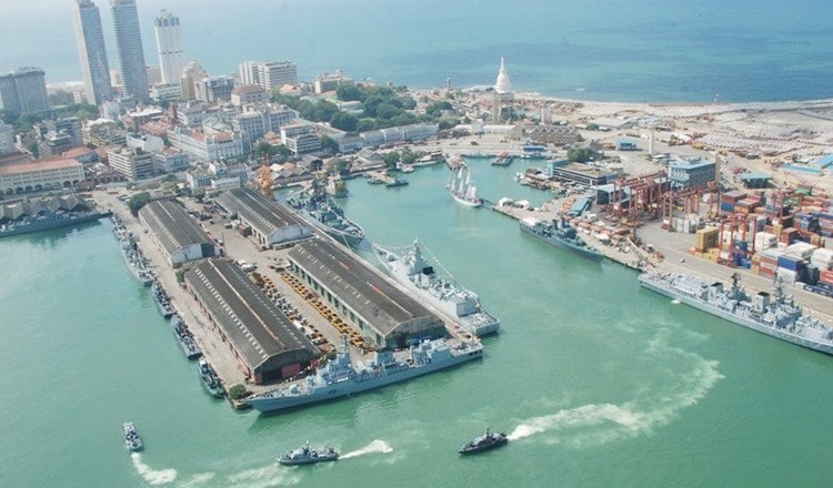
Port of Colombo
Colombo Port is a rapidly growing maritime hub of the South Asia Region. Cargo originating from and destined to Europe, East and South Asia, the Persian Gulf, and East Africa is conveniently and efficiently connected through the Colombo Port. The Colombo Port is primarily a container port. The original port had a harbor area of 184 hectares. In 2008, the South Harbor area (285 hectares) was developed to accommodate deep water berths and the latest generation of mainline vessels. The harbour is served by a two-way channel with an initial depth of 20m and a width of 570m. Since 1918, the Port of Colombo had been administered by the Colombo Port Commission, a Government Department which was made responsible for the supply and maintenance of cargo-handling equipment and other infrastructure, pilotage services, docking and slipping. The government had funded all its activities. Stevedore and shore handling activities were in the hands of several private Wharf age Companies. In 1958, the Port Cargo Corporation was set up to take over these activities performed by a multiplicity of operators. The Port Tally and Protective Services Corporation was formed in 1967 in order to perform on-board tallying and watchmen services on behalf of Agents.
Port of Hambantota
The Port of Magampura is Sri Lanka’s newest port declared opened on 18th November 2010 and is the southernmost port. Ancient Greek navigators knew of this safe anchorage and from this information Ptolemy named it Dionysil on his map of Thaproban. At present it caters to bulk cargo and other port related industrial activities. With Hambantota within a few nautical miles of the world’s busiest shipping lane, it is ideally located directly at the intersection of major international sea trading routes. The approach channel width is 210 meters and depth 17 meters. Two lighthouses guide vessel entry into the port.
Port of Trincomalee
Trincomalee harbour is the second best natural harbour in the world and the available water and land area is about 10 times as much as the Port of Colombo. Trincomalee was tentatively identified to cater for bulk and break bulk cargo and port related industrial activities including heavy industries, tourism and agriculture etc. At present SLPA is in the process to re-develop Trincomalee as a metropolis growth centre. The British naval hero, Admiral Lord Nelson, described Trincomalee as the greatest harbour in the world, and it is hardly surprising that the Europeans were to battle for it on several occasions. At various times, the Portuguese, Danes, Dutch, French and the British held it due to its strategic location in the Bay of Bengal. As a result the Port of Trincomalee is steeped in history and legends. Trincomalee has the fifth largest natural harbour in the world with a water area of over 2,000 hectares. It is about 10 times larger than the Port of Colombo. There are many scenic bays and coves that border. its coastline in tranquil waters with some pristine beaches and overlooked by highlands. The Port of Trincomalee mainly handles bulk cargo and other port related industrial activities. It is also home to the Sri Lankan Eastern Command naval base. The Port operates on a 24×7 hour basis throughout the year, except on May Day and with only day light navigation at present.
Port of Galle
Galle Harbor is a natural harbour, located in Galle, south-western coast of Sri Lanka. Currently Galle port serves as one of the most active regional ports in the country and it is also the only Sri Lankan port that provides facilities for pleasure yachts. International yacht societies have recognized Galle harbour as one of the world’s best attractions for yachting. Galle harbour was a major harbour in the country, which was in use even during the pre-Christian times, but gained importance after the 12th century. By the 14th century, Galle harbour was the most important harbour in Sri Lanka and retained its importance until 1873 when an artificial harbour was built in Colombo. After the construction of Galle Fort in the 17th century Galle port was a major port in the Indian Ocean for more than 200 years, which was an important anchorage for boats and ships traveling between Europe and Asia. When the British colonial government constructed breakwaters in the Colombo Harbour in late 19th century, much international marine traffic shifted to Colombo from Galle. Thereafter Galle port became a secondary port of the country, though it still handles some ships and boats. The ancient Port of Galle has a natural harbour and is protected by a rocky promontory called Point De Galle. The Portuguese first arrived in Galle in 1587 and built a small-fortified settlement here. It was after the Dutch captured Galle in 1640 that it achieved its greatest prosperity and today it is the surviving Dutch architecture of the 17th and 18th centuries, which lends Galle its charm. Although the entrance to the port was dangerous due to submerged rocks and reefs, Galle was the main port of the island until the rise of the Port of Colombo in 1875 after the construction of breakwaters in the development of Colombo harbour. The Port of Galle having a water area of 320 hectares provides mooring facilities for two alongside vessels. Pleasure yachts are accommodated. In addition, the port provides excellent opportunity for principals to carry out offshore ships supply services.
Port of Point Pedro
Point Pedro located in Jaffna District. Cotton is produced around Point Pedro in the fertile calcic red latosol soils. The eastern coast of Point Pedro forms a 3 mile wide, 20 mile long beach with sand dunes up to 100 feet high, extending to Thalayady. The porous soil has a water table deep underground with an estimated one billion litres of fresh water. Point Pedro has a small harbour, which is controlled by the Sri Lankan army. If the much-delayed and frequently re-planned Sethusamudram Shipping Canal Project is completed, deepening the Palk Straits between India and Sri Lanka to allow larger ships to pass, rather than having to travel 650 km around Sri Lanka, then Point Pedro and other ports in the Jaffna peninsula may see a significant increase in maritime trade, especially with India.
Kankasanthurei Harbour
Another urgent rehabilitation and improvement project was planned for Kankesanthurai (KKS) Harbour, The project is planned to repair and rehabilitate the existing breakwaters, piers and roads including dredging and wreck removal and construction of a new pier. The dredging in turning basin up to depth of 8m has already been completed to ensure cargo handling work continuously without interruption. Kankasanthurei is a port suburb, fishing division and resort hub of the Jaffna District. Formerly an electoral district. Kankasanthurei is home to the kankasanthurei beach, Kankesanthurai beach, Keerimalai Naguleswaram Temple (a Pancha Ishwaram) and the Maviddapuram Kandaswami Temple. The port’s harbour has served as an arrival and departure point for pilgrims since classical antiquity and is named after the Sri Lankan Tamil god Murukan. Kankesanthurai suburb has many fishing villages and Grama Niladhari (village officers) and is a northern part of Valikamam, one of the three regions of ancient habitation on the Jaffna Peninsula, located on the peninsula’s northern coast, 12 miles from Jaffna city, 85 miles from Mannar and 155 miles from Trincomalee.
Oluvil Port
Government of Sri Lanka, in its plan to give impetus to economic development in the Eastern region, has decided to build a port at a site in Oluvil. Under the “Nagenahira Navodaya” Programme which was launched to expedite the development activities in the region, higher priority was given for the Oluvil Development Project which will no doubt be an economic infrastructure the catalyst for the growth of the Eastern Region of Sri Lanka. This port will form the south eastern link in the developing chain of coastal harbours in the country and will provide more convenient and cost effective access to and from the south eastern region for goods and cargo originating on the west coast. The Oluvil Harbour is a commercial and fishery harbour located in Ampara District. The port was opened on 1 September 2013, its construction having begun in 2008 under the Nagenahira Navodaya programme. It covers a land area of 60 hector acres in the first stage and 105 hector acres in the second stage. The harbour basin covers an area of 16 hector acres of the sea and spreads 1.2 km along the coast line. Simultaneously, the commercial harbour has enough depth to handle ships up to 5,000 metric tons and the fishery harbour can hold more than 250 fishing boats.